

Introduction
If your phone just buzzed with a PDS severe thunderstorm watch alert, you are probably wondering what makes this one different from the regular warnings you see every spring. That reaction is completely normal, and honestly, it is a smart one. Not all storm alerts carry the same weight, and this one sits near the very top of the danger scale.
A PDS severe thunderstorm watch is one of the most serious weather alerts the Storm Prediction Center can issue. PDS stands for “Particularly Dangerous Situation,” and that phrase alone should tell you something important. These watches are rare, and meteorologists do not use that label lightly. In this article, you will learn exactly what PDS means, how it differs from a standard watch or warning, what you should do when one is issued, and which states like Texas, Oklahoma, Kansas, Nebraska, and Missouri tend to see them most often.
What Does PDS Mean in a Severe Thunderstorm Watch?
PDS stands for Particularly Dangerous Situation. When meteorologists at the Storm Prediction Center add this tag to a severe thunderstorm watch, they are telling you that conditions are expected to be significantly worse than a typical severe weather event.
A standard severe thunderstorm watch means conditions are favorable for large hail and damaging winds. A PDS severe thunderstorm watch means those threats are expected to be extreme. We are talking about very large hail, potentially baseball sized or bigger, and wind gusts that can exceed 80 miles per hour. These are storms that can cause widespread, long-lasting damage across a large area.
The PDS designation is not common. It gets issued only a handful of times each year across the entire country. When you see it, take it seriously.
Is a PDS Severe Thunderstorm Watch Dangerous?
Yes, absolutely. This is not the kind of alert you scroll past or ignore while finishing dinner.
Here is what makes a PDS severe thunderstorm watch especially concerning:
- Hail can reach sizes that destroy vehicles and break through roofs
- Wind gusts can snap large trees and knock out power for days
- Storms can produce multiple tornadoes embedded within the system
- Visibility can drop to near zero within seconds during a storm
- Damage can happen faster than you expect, leaving little time to react
Standard severe thunderstorm watches are already serious. A PDS watch raises the stakes considerably. Meteorologists issue this alert when atmospheric conditions line up in a way that strongly favors intense, long-lived supercell storms. These are the types of storms that produce the most destructive weather.
What Is the Difference Between a PDS Watch and a Warning?
This is one of the most common questions people ask, and it is worth understanding clearly.
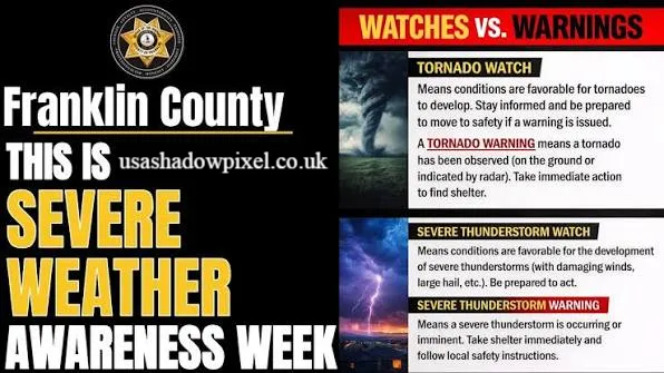
A watch means conditions are favorable for severe weather to develop. You have time to prepare, but severe weather has not started yet in your area. Think of a watch as a heads-up. You should be aware, have a plan ready, and monitor updates closely.
A warning means severe weather is happening right now or is about to happen imminently. A warning is issued when a storm has been confirmed by radar or a trained spotter. When a warning is issued, you need to act immediately.
A PDS watch sits at the top of the watch category. It signals that the storms that eventually develop could be historic in their intensity. In some cases, a PDS severe thunderstorm watch can even transition into a PDS tornado watch if the storm system evolves in that direction.
To put it simply:
- Watch: Prepare now, stay alert
- Warning: Take cover immediately
- PDS Watch: Prepare with extra urgency, conditions could be catastrophic
What Should You Do During a PDS Severe Thunderstorm Watch?
When a PDS severe thunderstorm watch is issued for your area, here is what I recommend doing right away.
Before the storms arrive:
- Charge your phone fully and have a portable charger ready
- Identify the safest room in your home, ideally an interior room on the lowest floor
- Move vehicles into a garage if possible, since hail in these events can be massive
- Fill a bag with essentials: water, medication, flashlight, and important documents
- Turn on a NOAA weather radio or download a reliable weather app with alerts enabled
During the watch:
- Stay indoors and keep monitoring weather updates
- Avoid driving unless absolutely necessary
- Keep pets inside and secure
- Stay away from windows, especially during storm passages
- If a warning is issued, move to your safe room immediately
After storms pass:
- Watch for downed power lines and avoid walking through standing water
- Check on neighbors, especially elderly or disabled individuals
- Document any damage with photos before beginning cleanup
How Long Does a PDS Severe Thunderstorm Watch Last?
Most severe thunderstorm watches last anywhere from four to eight hours. A PDS severe thunderstorm watch typically falls within the same timeframe, though the Storm Prediction Center can extend or cancel a watch depending on how conditions evolve.
The watch remains in effect until it expires or until it is cancelled by the issuing office. Cancellations happen when the threat diminishes faster than expected. Extensions happen when the atmosphere remains volatile longer than originally forecast.
You should not assume the danger is gone just because a couple of hours have passed. Keep monitoring updates throughout the entire watch period and pay close attention when storm cells begin moving into your county.
States Most Affected: The PDS Hot Zones
Certain states experience PDS severe thunderstorm watches far more often than others. If you live in any of these areas, it is worth building a solid severe weather plan before the season begins.
Texas
Texas is one of the most storm-prone states in the country. The combination of Gulf moisture, dry air from the west, and strong wind shear creates ideal conditions for violent thunderstorms. PDS watches are not uncommon across north and central Texas during spring and early summer.
Oklahoma
Oklahoma sits directly in the heart of Tornado Alley and sees some of the most intense supercell thunderstorms on the planet. The state has experienced numerous PDS events that produced massive hail and violent tornadoes embedded in larger storm systems.
Kansas
Kansas shares much of the same atmospheric recipe as Oklahoma. Wide open plains, strong jet stream support, and frequent clashes between warm and cold air masses make Kansas a frequent target for PDS level events.
Nebraska
Nebraska, especially the southern and central portions, sees dangerous supercell activity every spring. The storms that form across Nebraska can produce hail the size of softballs and spawn significant tornadoes.
Missouri
Missouri often sits at the eastern edge of severe weather outbreaks. Storms that begin in Kansas and Oklahoma frequently move into Missouri with tremendous energy still intact. PDS watches covering Missouri are typically associated with large, organized storm systems.
Conclusion
A PDS severe thunderstorm watch is not something to take lightly. It is the weather community’s way of telling you that what is coming could be significantly worse than what you are used to seeing. Understanding what PDS means, knowing the difference between a watch and a warning, and having a clear action plan can genuinely make a difference in your safety.
Whether you live in Texas, Oklahoma, Kansas, Nebraska, Missouri, or anywhere else in the country, storm preparedness starts before the clouds roll in. Do not wait for a warning to start thinking about what you will do. Have your plan ready, keep your phone charged, and stay informed.
Have you ever experienced a PDS severe thunderstorm watch in your area? Share your story or pass this article along to someone who could use this information before storm season kicks into gear.
Frequently Asked Questions
1. What does PDS stand for in weather? PDS stands for Particularly Dangerous Situation. It is a special tag added to watches when atmospheric conditions are expected to produce extreme, life-threatening weather.
2. How rare is a PDS severe thunderstorm watch? Very rare. The Storm Prediction Center issues only a small number of PDS severe thunderstorm watches each year across the entire United States.
3. Is a PDS watch worse than a tornado watch? Not necessarily worse, but equally serious in its own category. A PDS severe thunderstorm watch can sometimes evolve into a PDS tornado watch as conditions change.
4. Can a PDS severe thunderstorm watch produce tornadoes? Yes. Large, intense thunderstorm systems covered by PDS watches can and sometimes do produce tornadoes, especially supercell storms that develop within the watch area.
5. What hail size is typical in a PDS severe thunderstorm event? Hail in PDS events can range from golf ball size to baseball size or even larger, capable of destroying vehicles, roofs, and crops.
6. Should I evacuate during a PDS severe thunderstorm watch? Evacuation is not typically required for a watch. However, you should shelter in a sturdy building, move to an interior room, and be ready to take immediate cover if a warning is issued.
7. How do I receive a PDS watch alert on my phone? Wireless Emergency Alerts are sent automatically to cell phones in the affected area. You can also download weather apps like Weather.com or the official NWS app for more detailed notifications.
8. Can a PDS watch be issued at night? Yes. Nighttime PDS events are especially dangerous because many people are asleep and may not hear alerts. A weather radio with an alarm is highly recommended for overnight storm threats.
9. Who issues PDS severe thunderstorm watches? The Storm Prediction Center, which is part of the National Weather Service, is the only agency authorized to issue PDS watches for the contiguous United States.
10. What is the difference between a severe thunderstorm watch and a PDS severe thunderstorm watch? A standard watch indicates favorable conditions for severe storms. A PDS watch indicates conditions are favorable for exceptionally violent storms capable of causing widespread, significant damage.
About the Author: Sarah Monroe is a weather safety writer and communicator with over eight years of experience translating complex meteorological data into practical, reader-friendly guidance. She has covered severe weather events across the Great Plains and Gulf Coast regions, working closely with emergency management professionals to help everyday people understand and respond to weather threats. When she is not writing about storm preparedness, Sarah volunteers with her local community emergency response team.
email: johanharwen@314gmail.com
Author Name: Sarah Monroe